
Five thousand-metre peaks, no crowds, and a guesthouse dinner waiting at the end of the trail. Georgia’s Greater Caucasus holds some of the finest mountain trekking anywhere in Europe — and most hikers have never heard of it.
While the Dolomites and Mont Blanc routes fill to capacity every July, trails in Svaneti, Tusheti, and Kazbegi stay remarkably quiet. You can walk for three days through glaciated valleys and medieval tower-house villages, passing shepherds and wildflower meadows, without seeing another group. The infrastructure is simpler than the Alps — that is part of the appeal — but the mountains are just as serious. Peaks here reach over 5,000 metres. River crossings can be knee-deep in June. Some passes stay snowbound until mid-July.
This is not adventure tourism wrapped in cotton wool. It is real mountain trekking in a country that still feels undiscovered.
Below you will find detailed descriptions of every hiking trail and trekking tour we run — from half-day glacier walks near Mestia to a 13-day expedition through the Eastern Caucasus. We have broken them down by region, compared difficulty levels, and included the practical information you actually need: what to pack, which medicines to carry, where your phone will and will not work, and which routes require a passport check.
Why Hikers Are Choosing Georgia Over the Alps
There is a reason Georgia keeps appearing on “where to trek next” lists. The mountains are enormous — Shkhara, the country’s highest peak, reaches 5,193 metres — but the logistics are surprisingly manageable. Tbilisi has direct flights from most European capitals, and from there you can reach even the most remote trailheads within a single day.
Cost is another factor. A night in a mountain guesthouse with dinner and breakfast runs 60–100 GEL (roughly $20–35). A guided week of trekking in Svaneti costs less than a long weekend in Chamonix. And you are not paying for a sanitised version of the mountains — you are paying for the real thing: home-cooked meals in stone houses, local guides who grew up on these trails, and landscapes that have not been redesigned for tourism.
What makes Georgia different from other Caucasus countries is the combination of access and wildness. The trails here cross living villages. In Tusheti, families still move their livestock up to summer pastures on foot every June. In Svaneti, the defensive towers that dot the valley floors have been standing since the 9th century — and people still live beside them. You are not walking through a park. You are walking through a culture.
Trekking Regions and Trails: A Complete Guide
Georgia’s hiking trails spread across five distinct mountain regions, each with a different character, difficulty profile, and landscape. Choosing between them depends on how many days you have, how fit you are, and what kind of scenery calls to you — glaciers and tower-villages, or volcanic plateaus and subalpine forest.
Svaneti — The Iconic Trekking Region
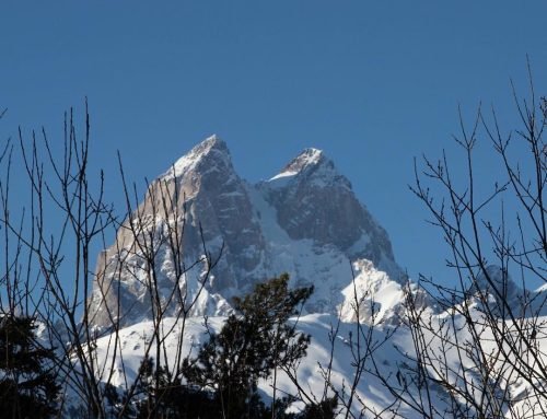
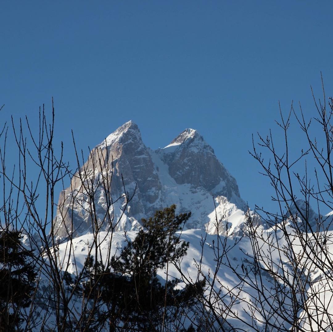
If you have only one week for trekking in Georgia’s mountains, spend it in Svaneti. This is the country’s flagship hiking region, and for good reason: a concentration of glaciated peaks (Ushba at 4,710m, Tetnuldi at 4,858m, Shkhara at 5,193m), flower-filled alpine meadows, and the extraordinary Svan tower-house villages that earned Upper Svaneti its UNESCO World Heritage status.
The base town of Mestia sits at around 1,500 metres and has a small airport with flights from Tbilisi (weather-dependent) as well as road access from Zugdidi. From here, trails fan out in every direction — south toward Ushguli, east to the Chalaadi Glacier, west into the Latali communities, and up to Koruldi Lakes at nearly 3,000 metres.
Svaneti has the best trail infrastructure in Georgia. Guesthouses operate in most villages along the trekking routes, serving enormous dinners of kubdari (meat-stuffed bread), bean stews, and local cheese. You do not need a tent for the classic routes — though you do need legs that can handle 800–1,200 metres of daily elevation gain.
Mestia to Ushguli Trek (4 trekking days)
The single most popular multi-day trek in the country, and it has earned that reputation. The route follows a chain of Svan villages — Zhabeshi, Adishi, Iprali, Ushguli — through a landscape that shifts from dense forest to open alpine pasture as you move south. The highlight of the route is the crossing of the Chkhutnieri Pass at roughly 2,750 metres, where the view opens to a wall of glaciated five-thousanders stretching across the horizon.
The trail itself is well-defined but not always easy. The descent from Chkhutnieri into the Khalde valley is steep and loose in places. River crossings after Adishi can be tricky in early season when snowmelt is at its highest — horses are sometimes used to help trekkers across. Guesthouses in Adishi, Iprali, and Ushguli provide meals and beds, so you can walk with a relatively light pack.
Ushguli, the endpoint, claims to be the highest continuously inhabited settlement in Europe at around 2,200 metres. Whether or not that is technically true (there is some debate), the village is extraordinary: a cluster of medieval towers against a backdrop of Shkhara’s glaciers. Plan to spend at least half a day exploring before the drive back.
Difficulty: Moderate. The Chkhutnieri Pass crossing is the crux day — roughly 7–8 hours with 1,000m+ of ascent. Other days are more relaxed. Prior multi-day hiking experience recommended but not required.
Svaneti Forests Trek: Lakhushdi to Adishi
This is the route for hikers who have already done Mestia–Ushguli and want to see Svaneti from a different angle — or for those who prefer trails with fewer people on them. The trek starts in the old village of Lakhushdi in the Latali community and crosses the Zuruldi Range, which separates the wild Enguri gorge from the Mestiachala valley. It finishes in Adishi.
The terrain here is different from the classic route: thicker forest, steeper ridges, fewer open valleys. You are walking through birch and spruce, not meadows. It feels wilder and less travelled. This trail does not visit Ushguli, which may be a drawback for first-timers but is precisely the point for those looking for solitude.
Difficulty: Moderate to challenging. Trail is less established than the Mestia–Ushguli route. Navigation can be tricky in forest sections. A guide is strongly recommended.
Full Svaneti Trekking Experience (8 days)
Our most comprehensive Svaneti itinerary combines the Mestia–Ushguli route with additional hiking in the Enguri valley, the Mulkhura gorge, and visits to less-frequented villages. Eight days allows you to walk deeper into the region — reaching glaciers, crossing higher passes, and spending time in communities that most four-day trekkers never see.
This is the option for hikers who do not want to rush. Rest days are built in, and the pace allows for side trips to viewpoints and glacier approaches that shorter tours skip.
Difficulty: Moderate, with some challenging days. Cumulative elevation and distance make this a tour for reasonably fit hikers.
Chalaadi Glacier Hike (half day)
The shortest and easiest trekking option near Mestia. A well-worn trail follows the Mestiachala River upstream to the snout of the Chalaadi Glacier — a river of blue-white ice wedged into a narrow valley between steep rock walls. The walk takes roughly two to three hours each way, with minimal elevation gain.
This is an excellent warm-up hike or a standalone option for travellers who only have a day in Mestia. The final approach to the glacier involves crossing some rocky moraine, but nothing technical.
Difficulty: Easy. Suitable for families and anyone with basic fitness.
Koruldi Lakes Hike (full day)
The classic day hike from Mestia. A steep climb through forest and then open meadow leads to the Koruldi Lakes at approximately 2,740 metres, where the reflection of Mount Ushba in the water on a clear day is one of the most photographed views in Georgian trekking.
The ascent is relentless — about 1,200 metres of vertical gain from Mestia — so do not underestimate it despite being a day hike. Most groups take 6–8 hours round-trip. The reward, apart from the view, is the carpet of wildflowers in July and the sense of standing at the edge of something vast.
Difficulty: Moderate to challenging (due to steep, sustained ascent). A good test piece if you are preparing for a longer trek.
Shkhara Glacier Trek from Ushguli (full day)
From the high village of Ushguli, a trail follows the valley southeast toward the foot of Shkhara — Georgia’s highest mountain at 5,193 metres. The walk approaches the glacier tongue through moraine fields and braided river channels, with the massive south face of Shkhara looming overhead.
This is wilder and more committing than Chalaadi. The terrain underfoot is rougher, distances are longer, and you are walking toward a serious mountain. On a clear day, the scale of Shkhara’s glaciers is almost difficult to process. This trail pairs naturally with the Mestia–Ushguli trek as a bonus day at the end.
Difficulty: Challenging. Long day, rough terrain, high altitude. Not technically difficult, but physically demanding.
Guri Mountain Hike from Ushguli (half to full day)
A ridge walk above Ushguli offering panoramic views of the entire upper Enguri valley and the Greater Caucasus main chain. The hike ascends to the Guri summit, from where you can see Shkhara, Tetnuldi, and the sprawl of tower-villages below. It is shorter and less strenuous than the Shkhara Glacier trek, making it a good option for those spending a rest day in Ushguli.
Difficulty: Easy to moderate.
Latali Cultural Hike (full day)
A lighter option that mixes hiking with cultural experiences — visiting the Lakhushdi community, seeing Svan medieval churches, learning local gold-panning traditions, and joining a cooking class. The hiking component is gentle and through lower-altitude forest and pasture. A good choice for those who want to combine trekking with deeper cultural engagement, or for rest days between bigger efforts.
Difficulty: Easy. Suitable for all fitness levels.
5-Day Svaneti Tour: Mestia, Ushguli & Hidden Villages
A hybrid tour combining moderate day hikes with jeep transfers and cultural visits. Five days, four nights. The itinerary covers the major Svaneti highlights — Mestia, Ushguli, several less-visited communities — without requiring you to carry a pack between villages. This is ideal for hikers who want to see the region thoroughly but prefer not to do a continuous multi-day trek.
Difficulty: Easy to moderate. Day hikes only, no overnight camping.
Tusheti & the Eastern Caucasus — Remote, Raw, Unforgettable
If Svaneti is Georgia’s most famous trekking region, Tusheti is its most dramatic introduction to true isolation. Tucked behind the Greater Caucasus main ridge in the northeast corner of the country, Tusheti is accessible only by a mountain road that opens in late June (or sometimes early July) once the Abano Pass — at 2,926 metres, the highest drivable pass in the Caucasus — clears of snow. When that road closes in October, the region is cut off entirely.
The landscape here is different from Svaneti: drier, more open, with broader valleys and sharp-edged ridges rather than glaciated massifs. Defensive tower-villages — Omalo, Dartlo, Chesho, Diklo — cling to hillsides above deep gorges. The flora shifts from Svaneti’s lush subalpine meadows to steppe-like grasslands dotted with wild herbs. In early summer, the passes glow with rhododendron.
Fewer tourists reach Tusheti, and it shows. The trails are quieter, the guesthouses simpler, the sense of remoteness more complete. Wildlife sightings — eagles, chamois, occasionally wolves — are more common here than anywhere else in hiking-accessible Georgia.
Hiking in Tusheti: Adventures in the Wild (4 days)
Our core Tusheti trek, visiting the main valley villages and crossing high pastures between Omalo and Dartlo. Four days gives you enough time to absorb the slow rhythm of the region — walking between villages, eating enormous supras (feasts) at guesthouses, and watching sunset paint the tower-houses gold.
The trail passes through varied terrain: open ridge walks with views across the Alazani valley, descents into narrow gorges, and forest stretches where the canopy closes overhead. Days are moderate in length but the altitude (mostly 1,800–2,400 metres) adds effort.
Difficulty: Moderate. Good trail conditions, moderate distances. The access road to Omalo is the most nerve-wracking part of the trip.
Atsunta Pass Trek (7 days)
This is one of the great mountain crossings of the Caucasus. The trail connects Tusheti (in the east) with Khevsureti (to the west), traversing the main ridge of the Greater Caucasus via the Atsunta Pass at 3,431 metres. It is the highest and most exposed pass crossing on any of our trekking routes.
The trek starts from Omalo in Tusheti and follows the Alazani valley upstream before beginning the long ascent to the pass. The final approach is steep, often on loose scree and late-season snow. At the top, you stand on the spine of the Caucasus — Georgia to the south, the Russian border just to the north. The descent into Khevsureti leads through a completely different landscape: narrow gorges, ruined medieval fortresses, and the striking village of Shatili with its stone fortifications.
Seven days allows for proper acclimatisation and rest. This is not a route to rush. Weather can close the pass with little warning — flexibility in the schedule is essential.
Difficulty: Challenging. High altitude, exposed pass, demanding terrain. Prior high-altitude trekking experience required. Fitness level should allow 8–10 hours of walking with significant elevation changes.
Grand Trek in Eastern Caucasus (13 days)
Our most ambitious expedition. Thirteen days through the Eastern Caucasus, combining the Tusheti valleys with the Atsunta Pass crossing and extended exploration of Khevsureti and surrounding ranges. This trek takes you into terrain that few organised groups ever reach — high ridgeline walking, remote side valleys, and nights camping far from any village.
The Grand Trek is designed for experienced mountain hikers who want the full Caucasus experience: not just the highlights, but the long empty stretches between them. Expect some days of 8+ hours of walking, passes above 3,000 metres, and conditions that require self-sufficiency.
Difficulty: Very challenging. Multi-day camping, high passes, long distances. This is a serious mountain expedition. Prior multi-day trekking experience at altitude is essential.
Kazbegi & the Khevi Region — High Mountains, Easy Access
Stepantsminda (still called Kazbegi by most locals and every taxi driver) sits just three hours from Tbilisi on the Georgian Military Highway — one of the oldest road routes through the Caucasus. The town lives in the shadow of Mount Kazbek (5,047 metres), a dormant stratovolcano whose summit glaciers are visible from the main square on a clear day.
This is the most accessible high-mountain scenery in Georgia. You can have breakfast in Tbilisi, be hiking by noon, and still sleep in a comfortable guesthouse with hot water that evening. Day hikes here are spectacular; multi-day options cross into the neighbouring Khevi and Khevsureti valleys.
Chaukhi Pass Hike: Juta to Roshka (2 days)
A compact but serious two-day trek linking the Juta valley (near Kazbegi) with the village of Roshka in Khevsureti, crossing the Chaukhi Pass at approximately 3,338 metres. The Chaukhi massif is a row of jagged dolomite-like towers — the most dramatic rock formations in the Georgian Caucasus — and the pass sits in the middle of them.
On the Juta side, the trail climbs through alpine meadow to the Abudelauri Lakes — three small lakes, each a different colour (green, blue, white) depending on the mineral content and light. From the lakes, the path ascends steeply to the pass through scree and occasional snow. The descent to Roshka is long and crosses exposed terrain.
Two days is the minimum. The first day covers the approach and lake visit; the second is the pass crossing and descent. For those with less experience, we can arrange a supported version with pack horses and an extended schedule.
Difficulty: Challenging. High pass, scree terrain, potential snow. Shorter than our other multi-day treks but technically more demanding per day.
Majestic Caucasus Mountains Tour (4 days)
A four-day guided tour of the Kazbegi region combining day hikes to Gergeti Trinity Church, Gveleti Waterfalls, and the Truso Valley with comfortable guesthouse accommodation. This is the right choice for hikers who want high-mountain scenery without multi-day trekking — or as an addition to a longer Georgia itinerary.
The Truso Valley walk deserves special mention: a broad, almost flat gorge with travertine terraces, mineral springs, and the ruins of a medieval settlement. It feels more like Iceland than the Caucasus. The walk to Gergeti Trinity Church — the iconic stone church at 2,170 metres with Kazbek behind it — takes about three hours round-trip and is manageable for most fitness levels.
Difficulty: Easy to moderate. Day hikes only, no passes.
Racha — The Quiet Mountains
Racha occupies a stretch of the Greater Caucasus between Svaneti and South Ossetia, and almost nobody treks here. That is both its appeal and its challenge: the trails are less established, the tourist infrastructure thinner, and the logistics trickier. But the landscape — dense deciduous forest, hidden alpine lakes, and wide glacial valleys — is magnificent.
Trekking in Racha Mountains (5 days)
A five-day trek through the Racha highlands, including the Gebi valley, passes above the treeline, and visits to communities that rarely see foreign visitors. Racha is known for its forests — thick stands of beech, fir, and spruce — and for producing Georgia’s most prized semi-sweet wine (Khvanchkara). The trekking here feels like stepping twenty years back in time compared to Svaneti.
The terrain mixes steep forested ascents with open ridgeline walking. Accommodation is in village guesthouses where it exists, and in tents where it does not. This trek requires a degree of flexibility and comfort with basic conditions.
Difficulty: Moderate to challenging. Less-established trails, some route-finding. A guide is essential.
Tobavarchkhili — The Silver Lake Trek
Tobavarchkhili (the name translates roughly as “silver lake”) sits beneath the Egrisi Range in western Georgia, on the border between Svaneti and Samegrelo. The lake itself, at around 2,650 metres, is stunning — a turquoise sheet of water surrounded by rocky peaks. But the approach is what gives this trek its reputation.
Tobavarchkhili Lake Trekking (6 days)
The route climbs through dense Colchic rainforest — the kind of dripping, moss-covered woodland that feels almost tropical — before breaking into alpine meadow and finally moraine. The elevation changes are significant, and the trail is poorly marked in places. Camping is required for at least some nights.
This is a trek for people who have already done Svaneti and Tusheti and want something different. The Egrisi Range does not have the same name recognition as the Greater Caucasus, but the raw landscape and the sense of discovery more than compensate.
Difficulty: Challenging. Steep terrain, poor trail marking, camping required. Physical fitness and prior trekking experience necessary.
Javakheti & Borjomi — Georgia’s Wild South
The southern highlands are a completely different world from the Greater Caucasus. Javakheti is a volcanic plateau at 1,700–2,000 metres, covered in grassland and scattered with lakes. The landscape resembles the Central Asian steppe more than anything you would expect to find in Georgia. Borjomi, to the north, is a forested spa town sitting at the entrance to one of Georgia’s largest national parks.
Javakheti & Borjomi Trek (8 days)
Eight days through southern Georgia’s contrasting landscapes: the open Javakheti plateau, the volcanic ridges of the Abuli range, and the dense forests of the Borjomi-Kharagauli National Park. This trek is unusual because it crosses two completely different biomes — high steppe and Colchic forest — in a single route.
The Borjomi-Kharagauli section is one of the few trekking areas in Georgia with well-maintained shelters and marked trails that meet international standards. The Javakheti section is more remote and requires camping. Wildlife is a genuine highlight here — the park supports populations of deer, chamois, and raptors.
Difficulty: Moderate to challenging. Long days, varied terrain. The Borjomi section is well-marked; the Javakheti section less so.
Trail Comparison: Difficulty, Duration, and Terrain at a Glance
Choosing the right trek depends on your experience, available time, and what kind of mountain landscape draws you. The table below compares every trail we operate across all five regions.
| Trek / Hike | Region | Duration | Difficulty | Max Elevation | Accommodation | Key Feature |
|---|---|---|---|---|---|---|
| Chalaadi Glacier | Svaneti | Half day | Easy | ~1,850m | N/A (day hike) | Glacier approach, river valley |
| Guri Mountain from Ushguli | Svaneti | Half–full day | Easy–Moderate | ~2,900m | N/A (day hike) | Panoramic ridge, tower village views |
| Latali Cultural Hike | Svaneti | Full day | Easy | ~1,600m | N/A (day hike) | Cultural immersion, light walking |
| Koruldi Lakes | Svaneti | Full day | Moderate–Challenging | ~2,740m | N/A (day hike) | Ushba views, alpine lakes |
| Shkhara Glacier from Ushguli | Svaneti | Full day | Challenging | ~2,700m | N/A (day hike) | Georgia’s highest peak approach |
| Chaukhi Pass: Juta–Roshka | Kazbegi | 2 days | Challenging | ~3,338m | Camping / guesthouse | Abudelauri Lakes, rock towers |
| Mestia to Ushguli | Svaneti | 4–6 days | Moderate | ~2,750m | Guesthouses | Classic route, Svan towers, glaciers |
| Svaneti Forests (Lakhushdi–Adishi) | Svaneti | 3–4 days | Moderate–Challenging | ~2,600m | Guesthouse / camping | Dense forest, quiet alternative route |
| Hiking in Tusheti | Tusheti | 4 days | Moderate | ~2,400m | Guesthouses | Remote villages, open valleys, wildlife |
| Caucasus Mountains Tour | Kazbegi | 4 days | Easy–Moderate | ~2,200m | Guesthouses / hotel | Kazbek views, Gergeti Church, Truso |
| 5-Day Svaneti Tour | Svaneti | 5 days | Easy–Moderate | ~2,200m | Guesthouses | Mix of hikes, jeep tours, culture |
| Trekking in Racha | Racha | 5 days | Moderate–Challenging | ~3,000m | Guesthouse / camping | Untouched forests, no crowds |
| Tobavarchkhili Lake | Samegrelo/Svaneti | 6 days | Challenging | ~2,700m | Camping | Silver lake, Colchic rainforest |
| Atsunta Pass | Tusheti–Khevsureti | 7 days | Challenging | ~3,431m | Camping / guesthouse | Major ridge crossing, border zone |
| Svaneti Trekking Experience | Svaneti | 8 days | Moderate | ~2,800m | Guesthouses | Comprehensive Svaneti exploration |
| Javakheti & Borjomi | Southern Georgia | 8 days | Moderate–Challenging | ~2,500m | Shelters / camping | Volcanic plateau, national park forest |
| Grand Eastern Caucasus | Tusheti–Khevsureti | 13 days | Very Challenging | ~3,500m | Camping / guesthouse | Full Eastern Caucasus expedition |
How to Choose: A Decision Guide by Experience Level
First time trekking? Start here. The Chalaadi Glacier hike and the Mestia–Ushguli trek are the safest introductions to hiking in Georgia’s mountains. Both have good trail infrastructure, guesthouse accommodation, and manageable distances. The 4-day Caucasus Mountains tour near Kazbegi is another excellent option — spectacular scenery with day hikes only.
Experienced hiker looking for a challenge? The Atsunta Pass trek and the Chaukhi Pass crossing will test your mountain legs. Both involve passes above 3,300 metres, exposed terrain, and conditions that demand proper equipment and fitness. Tobavarchkhili adds route-finding challenges to the mix.
Short on time? The Koruldi Lakes day hike packs more altitude gain and visual reward into six hours than most full-day hikes anywhere in Europe. The 2-day Chaukhi Pass trek is the most efficient way to experience a genuine Caucasus pass crossing.
Want cultural depth with your hiking? The 5-Day Svaneti Tour and the Hiking in Tusheti package both balance walking with village life, food, and architecture. The Latali tour is the most culturally focused single-day option.
Want the full expedition? The 13-day Grand Trek in Eastern Caucasus is our flagship expedition. Nothing else we offer comes close in terms of duration, remoteness, or the sense of being truly deep in the mountains.
When to Go: Season Guide for Trekking in Georgia
| Month | Conditions | Best For | Notes |
|---|---|---|---|
| June | Snow still present on high passes. Rivers running high. Wildflowers beginning. | Lower-altitude Svaneti hikes, Kazbegi day hikes | Tusheti road may not be open until late June. Atsunta and Chaukhi passes may be impassable. |
| July | Peak wildflower season. Passes mostly clear. Longest daylight hours. Occasional thunderstorms. | All treks. Best month for high passes (Atsunta, Chaukhi). | Warmest month — can be hot at lower altitudes. Book guesthouses in advance for Mestia–Ushguli. |
| August | Warm and stable. Late-season flowers. Rivers lower and easier to cross. | All treks, especially Tusheti and Eastern Caucasus. | Peak tourist season in Svaneti. Slightly busier trails on the Mestia–Ushguli route. |
| September | Cooling temperatures. Autumn colours beginning. Clear skies. Shorter days. | Svaneti, Kazbegi, Javakheti & Borjomi. | Tusheti road may close mid-to-late September. High passes become risky after mid-month. |
| October | First snow on passes. Cold nights. Spectacular autumn foliage at lower elevations. | Kazbegi day hikes, Borjomi-Kharagauli. | Multi-day high-altitude treks generally not recommended after early October. |
The core trekking season runs mid-June through mid-September. July and August are the safest months for high passes and the most reliable for weather. September offers quieter trails and golden light but shorter days and increasing cold at altitude.
Packing List for Trekking in Georgia
Mountain weather in the Caucasus changes fast. At 3,000 metres, you can move from warm sunshine to freezing rain in under an hour. Pack for layering, not for any single temperature. The goal is a pack that weighs under 12 kg (for guesthouse treks) or under 18 kg (if carrying camping gear).
Clothing
- Base layers (2 sets): Merino wool or synthetic. Avoid cotton — it holds moisture and chills you when wet.
- Insulating mid-layer: Fleece or lightweight down jacket. Essential for passes and evening temperatures.
- Waterproof shell jacket: With sealed seams and a hood. Afternoon rain is common in July and August.
- Waterproof trousers: Lightweight packable overtrousers for pass crossings and rain.
- Trekking trousers: Quick-drying, not jeans. Zip-off legs are practical for temperature changes.
- Warm hat and lightweight sun hat: Both needed. Nights above 2,500m can drop below zero even in July.
- Gloves: Lightweight liner gloves minimum. Warmer pair for passes above 3,000m.
- Gaiters: Useful for scree slopes and early-season snow (Atsunta, Chaukhi).
Footwear
- Trekking boots: Ankle-supporting, waterproof, well broken-in. This is non-negotiable. Georgian trails are rocky and uneven.
- Camp shoes or sandals: For river crossings and guesthouse evenings. Teva-style sandals work well.
- Trekking socks (3 pairs): Merino wool blend. Blisters end treks; good socks prevent them.
Equipment
- Backpack (35–50L): 35L for guesthouse treks, 50L+ if carrying camping equipment.
- Trekking poles: Highly recommended. River crossings, steep descents, and scree slopes all benefit from poles.
- Headlamp: With spare batteries. Essential for early starts and late arrivals at guesthouses.
- Water bottles (2L capacity): Water sources are available on most trails but carry enough between them. A portable filter is wise.
- Sunscreen (SPF 50) and sunglasses: UV intensity is high above 2,500 metres.
- Waterproof dry bags: For electronics, passport, and spare clothing.
- Sleeping bag liner: Guesthouse bedding varies. A silk or cotton liner adds comfort and warmth.
For Camping Treks
- Tent: Provided on our guided camping treks, but confirm with your tour details.
- Sleeping bag: Rated to -5°C minimum for summer high-altitude camping. Down or synthetic.
- Sleeping mat: Inflatable or foam. Nights on rock are cold without insulation beneath you.
Health, Medicines, and First Aid on the Trail
There are no pharmacies in the mountains, and medical help can be a day’s walk away. Carrying a basic personal medical kit is not optional — it is part of being prepared. The medicines listed below are available over the counter in Tbilisi pharmacies and are not restricted for import into Georgia in personal quantities.
Recommended Personal Medicine Kit
- Ibuprofen (400mg) or Paracetamol: For headaches, altitude-related discomfort, muscle pain, and reducing inflammation. Carry at least a 10-day supply.
- Oral rehydration salts (ORS): Essential after any bout of diarrhoea, heavy sweating, or altitude sickness symptoms. Lightweight, easy to carry.
- Loperamide (Imodium): For diarrhoea. Mountain water is generally clean in Georgia, but changes in diet and water source can cause stomach upset.
- Antihistamines (Cetirizine or Loratadine): For insect bites, allergic reactions, and hay fever (wildflower meadows in July can trigger pollen sensitivities).
- Broad-spectrum antibiotic (Azithromycin or Ciprofloxacin): Carry a short course in case of severe gastric infection or wound infection when medical help is distant. Consult your doctor before your trip.
- Blister plasters (Compeed or similar): Carry several sizes. Apply at the first sign of a hot spot — waiting makes things worse.
- Antiseptic wipes and wound closure strips (Steri-Strips): For cleaning and closing minor cuts. Scratches from rock and thorns are common.
- Elastic bandage and athletic tape: For sprains, joint support, and securing dressings.
- Diamox (Acetazolamide): Recommended for treks crossing passes above 3,000 metres (Atsunta, Chaukhi). Begin taking it 24 hours before reaching high altitude. Prescription required in some countries — arrange before travel.
- Sunburn cream or aloe vera gel: High-altitude sunburn is more intense than most people expect.
- Personal prescription medications: Bring more than you need in case of delays. Keep a written note of drug names (generic, not brand) in case you need to purchase replacements locally.
Electricity and Phone Connection in the Mountains
Georgia uses European-style Type C and Type F plugs (standard two-pin, 220V). Guesthouses in Mestia, Ushguli, Omalo, and Stepantsminda generally have electricity and wall sockets for charging, though power outages are not uncommon — especially in Tusheti and upper Svaneti during storms.
On the trail itself, there is no electricity. If your trek involves camping nights, you will need to bring your own charging solution — a power bank of at least 10,000 mAh is recommended. Some guesthouses along the Mestia–Ushguli route have limited sockets and may charge a small fee for use during peak season.
Mobile Phone Coverage
Georgia’s main mobile operators (Magti, Geocell/Silknet, and Beeline) provide reasonable coverage in towns and along major roads, but coverage drops off quickly once you leave the valleys. Here is what to expect by region:
- Mestia town: Reliable 4G. Coverage extends partially along the Mestia–Ushguli route, especially near villages (Zhabeshi, Adishi). Patchy or absent between villages and at higher elevations.
- Ushguli: Basic coverage (2G/3G). Enough for messages, often not enough for calls.
- Stepantsminda (Kazbegi): Good 4G coverage in town and along the Military Highway. Coverage drops on Chaukhi Pass and Juta valley trails.
- Tusheti (Omalo, Dartlo): Limited to no coverage. Omalo has intermittent 2G from a single tower. Beyond Omalo — including the Atsunta Pass route — assume no coverage at all.
- Racha: Sporadic coverage in the Gebi valley. No coverage on mountain trails.
- Tobavarchkhili: No coverage once you leave the access road.
- Javakheti plateau: Patchy coverage. Better near villages, absent on ridges.
Border Zones and Passport Requirements
Several hiking areas in northern Georgia run close to the Russian border and are designated as restricted zones. In practice, this mainly affects one route on our programme:
Atsunta Pass Trek (Tusheti–Khevsureti): This route crosses into a border zone. You must carry your passport at all times and may encounter border guard checkpoints. Failure to present a valid passport can result in being turned back or detained. Georgian citizens need their national ID card; all foreign nationals need a passport.
For other treks, carrying a passport is not legally required while hiking, but we strongly recommend having it on your person (in a waterproof pouch) at all times. Tusheti in general has occasional border guard presence, and having identification available avoids any potential issues.
No special permits are needed for entering Svaneti, Kazbegi, Racha, or Javakheti. The Tobavarchkhili route does not cross restricted zones but passes through remote territory — register your itinerary with us or with local authorities before setting out.
Getting to the Trailheads
All our treks begin and end with transfers from Tbilisi (or Kutaisi for Svaneti). Here is what the approach looks like for each region:
- Svaneti (Mestia): 8–9 hours by road from Tbilisi via Zugdidi, or 5–6 hours from Kutaisi. A small local airline operates Tbilisi–Mestia flights (40 minutes) but schedules are weather-dependent and frequently cancelled. Road transfer is the reliable option.
- Kazbegi (Stepantsminda): 3 hours from Tbilisi on the Georgian Military Highway. Paved road, spectacular scenery, easy logistics.
- Tusheti (Omalo): 10–12 hours from Tbilisi including the unpaved Abano Pass road (the last 70 km take 4–5 hours by 4×4). The road is open roughly late June to mid-September. There is no alternative land access.
- Racha (Gebi): 5–6 hours from Tbilisi via Kutaisi and the Racha valley road. The last section is unpaved.
- Tobavarchkhili: Access from the Samegrelo side. Roughly 6 hours from Tbilisi to the trailhead.
- Javakheti: 4–5 hours from Tbilisi heading south. Good roads to Akhaltsikhe, then local roads to the trailhead.
Frequently Asked Questions About Trekking in Georgia
Is trekking in Georgia safe?
Yes. Georgia is a safe country for trekking. The mountain regions have very low crime rates, and locals are notably hospitable to hikers. The main risks are natural — weather changes, river crossings, altitude — which is why we recommend guided treks for multi-day routes. Trails are not always well-marked, so navigation skills or a guide are important, particularly in Tusheti, Racha, and the Tobavarchkhili area.
Do I need a visa to trek in Georgia?
Citizens of the EU, UK, US, Canada, Australia, Israel, and many other countries can enter Georgia visa-free for up to one year. Check current visa requirements for your nationality before travel.
What fitness level do I need?
It depends on the trek. Day hikes like Chalaadi Glacier require only basic fitness. The Mestia–Ushguli route suits anyone who can walk 5–7 hours a day with a light pack on hilly terrain. For challenging routes like Atsunta Pass or the Grand Eastern Caucasus trek, you should be comfortable with 8–10 hour days carrying a pack at altitudes above 3,000 metres. Train on hills or stairs with a loaded pack for at least six weeks before a challenging trek.
Can I trek independently or do I need a guide?
The Mestia–Ushguli route can be done independently by experienced hikers with offline navigation. For all other multi-day routes — especially Atsunta Pass, Racha, Tobavarchkhili, and the Grand Eastern Caucasus — we strongly recommend a guide. Trails are unmarked or poorly marked, weather is unpredictable, and help is far away if something goes wrong.
Is altitude sickness a concern?
Most trekking in Georgia stays below 3,000 metres, where altitude sickness is rare. For passes above 3,000m (Atsunta at 3,431m, Chaukhi at 3,338m), mild symptoms — headache, fatigue, light nausea — are possible. Proper acclimatisation, hydration, and a gradual ascent profile manage the risk effectively. We build acclimatisation days into all itineraries that cross high passes.
What food is available on the trail?
Guesthouse treks (Svaneti, Tusheti, Kazbegi) include home-cooked meals: cheese-stuffed bread (khachapuri), bean stew (lobio), meat dumplings (khinkali), fresh salads, and locally made cheese and honey. The food is generous and filling — most hikers gain weight rather than lose it. On camping treks, our guides prepare meals. Vegetarian options are available but should be arranged in advance. Vegan meals are more challenging in mountain guesthouses.
When does the trekking season end?
The core season runs mid-June through mid-September. Lower-altitude treks in the Kazbegi area and Borjomi-Kharagauli can extend into October. High passes (Atsunta, Chaukhi) are safest in July and August. Tusheti becomes inaccessible once the Abano Pass road closes, usually by mid-to-late September.
How do I book a trekking tour?
Contact us through our booking form or email us directly at tours@georgia-tours.eu. We customise itineraries based on your dates, group size, and experience level. Private departures are available for all routes, and we can combine multiple regions into a single trip.
Start Planning Your Trek
Georgia’s Caucasus mountains are not going to stay quiet forever. The trails that feel empty today will be on every hiking list in five years. If you have been thinking about a trekking trip to the Caucasus, now is the time to go — before the paths widen and the guesthouses start taking reservations a year in advance.
Whether you want a gentle day hike to a glacier above Mestia or a two-week expedition through the Eastern Caucasus, we have been running these trails since 2010 and can put together exactly the right itinerary for your group. Get in touch — we will take it from there.